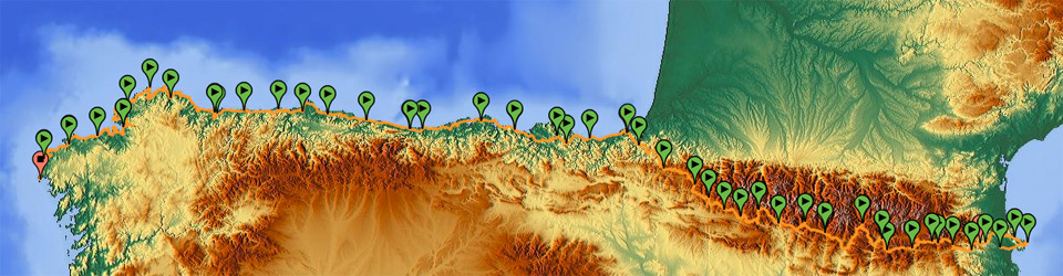
This website is a practical guide and a travel blog. It includes enough useful information to traverse the north of the Iberian Peninsula from coast to coast by mountain bike, that is to say, 2,400 km along ways, forest trails and roads, between the two most extreme points we can find: Cap de Creus in Catalonia, and Cabo da Nave in Galicia.
It shows and describes the route, with some pictures and written experiences of a 44-day holiday outdoor, as a route divided into stages, with an average of 50 km a day. It is a route planned for people with no special physical preparation, to be done by mountain bike, and with autonomous equipment, such as a saddlebag with a tent.
Who is this web site addressed to?
Well, it is addressed to curious people, and more specifically, to amateur mountain bikers who are looking for routes of several days around the north of the Iberian Peninsula, particularly around regions which are not very documented as a whole or regions about which there is good but fragmented information available, such as Asturias or Costa da Morte in Galicia.
To usual mountain bikers who want to do a Transpyrenean tour that is less demanding than the classic one as regards duration of stages, which focuses on spending nights in campsites, and with some route alternatives, for example, in the last stage, I suggest doing the last section of the Pyrenees along a greenway from Bera de Bidasoa.
To people who want to make the Northern or Coastal Route of the Way of St. James (Camino de Santiago), the new Sea Way, or the English Way by bicycle and along routes that are completely suitable for cycling. The route described in this website must run parallel to the Northern Route through the Basque Country, Cantabria, and Asturias, but has alternatives which break the current urban concept of the pilgrimage and get into places away from the usual pilgrim. In the case of Asturias, it recovers old itineraries of the Way which are no longer followed, and suggests visiting areas that are very well known locally but are not so aligned with the mass tourist interests.
What information will you find here?
You can find individual cards for each stage of the trip, with a brief description, the QR/BIDI code to download the GPS track, a link to Wikiloc to see the geographical context of a stage on the map, the distances, the towns you cross in the stage, and accommodation contact information (for campsites, hostels, lodges).
If you wonder why I have published this guide or how the GPS tracks have been created, you can read the section About me.
For summarized information about what we will find in each area and some practical tips for the route, take a look at the information divided by regions on the top menu, where you will also find the linked stages: Catalonian Pyrenees, Aragonese Pyrenees, Navarrese Pyrenees, Basque Country, Cantabria, Asturias, and Galicia.
As regards the Way of Saint James, each specific menu offers concise information of all the intersecting routes and some emblematic points to visit following our coast to coast Iberian route: the Pyrenees Route, the Northern Route, the Sea Route, the English Way, and the visit to the towns of Fisterra and Muxía.
If you want to download a GPS track, you can do it in each stage with the QR/BIDI or the link I provide, or you can go to Wikiloc and see the stages within the route and download it there.
Contact. To contact me, please ‘like’ us in Facebook and send a private message. In case you only want to receive updates or public comment, you can use the comments of this blog, or post to Facebook or Panoramio.