Category Archives: Daily

Daily stages of North Iberian coast to coast

Stage 5: Montagut i Oix – Camprodon

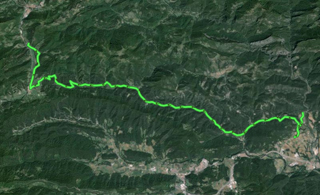
Montagut i Oix – CamprodonThis is a much easier stage than the previous one, and we reach a hill in northern Olot city to go to the area of natural interest of Alta Garrotxa through the south, and get into the Ripollès region. Garrotxa forest, very dark and wet, is the first area of lush vegetation we see during the trip, and we won’t see any other similar forest until Navarre, when we go through the Irati rainforest.

This is a quiet stage, with no surprises, but we have to be careful and pick up water during the way, since it will be hard to find sources if we do not know their location, though halfway, in Vall d’en Bac, we will find one just beside the road that can hardly be missed.

This trip is a few kilometres long, because when I went there, I wanted to visit Camprodon unhurriedly, so I arrived at a campsite a few kilometres before, called “Vall de Camprodon”, and once I settled in, I went to Camprodon for a walk and to have dinner. The campsite is closed out of season, but they allow camping in some plots during October.

Stage 5 in Wikiloc: http://en.wikiloc.com/wikiloc/view.do?id=4972225

GPS Track for Stage 5 download: http://goo.gl/5HCjMT

Distances: Càmping Montagut – Càmping Vall de Camprodon 36 km

List of villages:

Download track 5 with QR BIDI

Download track 5 with QR BIDI

Montagut
Sant Pau de Segúries
La colònia Estevenell
Camprodon

Price of accommodation: 17 euros.

References: Càmping Vall de Camprodon. Carretera C 38, Les Planes de Xenturri. 17867 Camprodon. Tel. +34.972740507 www.valldecamprodon.net

Etapa 5 en castellano · Etapa 5 en català

Stage 4: Sant Llorenç de la Muga – Montagut i Oix

Sant Llorenç de la Muga – Montagut i OixI don’t have any relevant pictures of this quite short stage. My mobile phone camera has been rendered useless almost all day until I got to Montagut campsite.
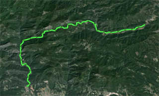
It is a hard stage; at least, during this stage, it is evident that you cannot go through the Pyrenees as if you were rambling along the beach. This is the day to go up and down Bassegoda hill, crossing the area of natural interest of Muga-Albanyà and Alta Garrotxa up to Montagut, which is down the plain. There are 10 km of continuous ascent with many slopes that cannot be climbed on a bike.

We should point out that, from “Bassegoda Park” campsite, at the beginning of the ascent, to Puig de Bassegoda, the topmost point, we will not find water. Going down Puig de Bassegoda, in a trail that is in very poor conditions at first, we will found a water source 5 km away from the point where we start the descent. While climbing up is so hard, climbing down is spectacular and dangerous, and there is no need to touch the pedals until “Montagut” campsite.

Stage 4 in Wikiloc: http://en.wikiloc.com/wikiloc/view.do?id=4972180

GPS Track for Stage 4 download: http://goo.gl/B8CjPI

Distances: La Fradera in Sant Llorenç de la Muga – Càmping Montagut: 33 km

List of villages:

Download track 4 with QR BIDI

Download track 4 with QR BIDI

Sant Llorenç de la Muga
Riberada d’amunt
Albanyà
Puig de Bassegoda
Sardenes
Montagut i Oix

Price of accommodation: 10 euros.

References: Càmping Monagut. Ctra. de Sadernes, km. 2 · 17855 Montagut i Oix. Tel. +34.972287202 www.campingmontagut.com

Etapa 4 en castellano · Etapa 4 en català

Stage 3: Llançà – Sant Llorenç de la Muga

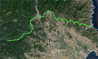
Llançà – Sant Llorenç de la MugaFrom Port de la Selva, I set off to Llançà, to the train station, in order to get to the initial point of the Trans Pyrenees tour. I intended to make a short stage of 30 km between Cap de Creus and Llançà, but I will make use of my time and will make one stage and a half.
I start going up the Pyrenees and see the varying landscapes until I am at a certain height, where the landscape is now unchanging, everlasting plains, somehow surrounding Sant Climent Sescebes. I get lost there, and appear below Vilartolí de Dalt, where there are curious metal sculptures made by a local artist.

I go back to the marked trail and get to the dolmens area, where Menhir de Vilartolí is: http://ca.wikipedia.org/wiki/Menhir_de_Vilartol%C3%AD

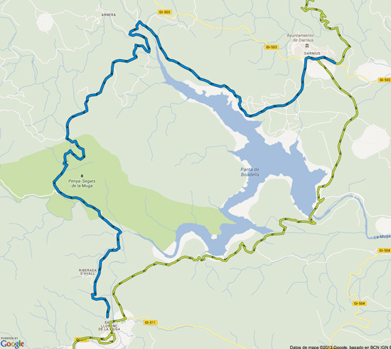
From this point, I go on towards Dornius, and this is the first minor change I make on the Transpyrenean route: when you get to Dornius, according to the classic Transpyrenean route, you should go northward, so that the Boadella Reservoir would be surrounded by a route of tracks in the northwest, and then going down towards Riberada d’Avall, and from that point, towards Sant Llorenç. Instead of taking that route, since the road surface was in poor conditions, I go through tracks that connect the southeast of the reservoir with Sant Llorenç de la Muga. This way is only 3 km shorter than the other, but plenty of time is saved and trails in poor conditions are avoided, and in my case, it was worth following this alternative route.

In the following graph, you can see the differences between the classic route —the top, blue line— and the alternative route through the reservoir —lower, green line.

Minor change of Transpyrenean (in green colour)

Minor change of Transpyrenean (in green)

At the time I am making this stage, early October, 2012, big forest fires have broken up throughout the Alt Empordà region not long ago, and many of the mountain bike trails have been destroyed, so I have to improvise alternative routes, and that effort means a considerable delay as regards the stages I have planned.

I stop in Sant Llorenç de la Muga to spend two nights there, in “La Fradera” campsite, and visit the area on the second day.

Etapa 2 a Wikiloc: http://en.wikiloc.com/wikiloc/view.do?id=4972036
Etapa 3 a Wikiloc: http://en.wikiloc.com/wikiloc/view.do?id=4972091

GPS Track for Stage 2 download: http://goo.gl/85Pt00
GPS Track for Stage 3 download: http://goo.gl/Ya5BJS

Distances:
Port de la Selva – Llançà: 8 km
Llançà – Sant Llorenç de la Muga: 64 km

List of villages:

Download track 3 with QR BIDI

Download track 3 with QR BIDI

Llançà
Vilamaniscle
Rabós
Espolla
Vilartolí
Cantallops
La Jonquera
Agullana
Darnius
Sant Llorenç de la Muga

Price of accommodation: 12 euros.

References: Càmping La Fradera. Ctra. Albanyà km 2. Sant Llorenç de la Muga. Tel. +34.972542054

Etapa 3 en castellano · Etapa 3 en català

Stages 1 and 2: Figueres – Cap de Creus – El Port de la Selva

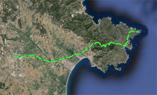
Figueres – Cap de CreusI started off at the train station in Figueres, which was the closest train station to go to Cap de Creus by bike.
Getting off in Figueres makes it easier to go to Cap de Creus as the first point, and then spend the night in Roses, Cadaqués, Port de la Selva, or Llançà.

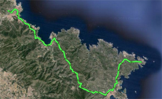
In my case, I went from Figueres to Cadaqués, where I found that the campsite I expected to be open had already closed due to end of season 24 hours before, so I went to Cap de Creus and, then, I spent the night in Port de la Selva, at “Port de la Vall” campsite.
Cap de Creus – Llançà
The track I provide here is a bit longer, since it is up to Llançà. It is because I changed the initial plan to stay in Port de la Selva. These changes on the go sometimes are reflected in the tracks I provide, and sometimes they won’t, for practical reasons, because in some cases, it is better to use standard, prearranged itineraries, and not my personal alternatives.


Stage 1 in Wikiloc
: http://en.wikiloc.com/wikiloc/view.do?id=4971946
Stage 2 in Wikiloc: http://en.wikiloc.com/wikiloc/view.do?id=4972036

GPS Track for Stage 1 download: http://goo.gl/Pzjjpb
GPS Track for Stage 2 download: http://goo.gl/85Pt00

Download track 1 with QR BIDI

Distances:
Figueres – Cap de Creus: 41 km
Cap de Creus – Port de la Selva: 29 km

List of villages:
Figueres
Castelló d’Empúries
Cadaqués
El Port de La Selva

Price of accommodation: 21 euros.

Download track 2 with QR BIDI

References:
Càmping Port de la Vall. Ctra. Llançà, km 6. El port de la Selva. Tel. +34.972387186 www.campingportdelavall.com

Etapas 1 y 2 en castellano · Etapes 1 i 2 en català