Category Archives: Daily

Daily stages of North Iberian coast to coast

Stage 44: Muxía – Fisterra

Muxía – Fisterra
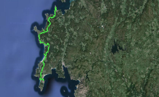
This is the last stage of our route, and it is short and nice to do. Then, we have different alternatives to leave Costa da Morte, although I will go to Santiago de Compostela by road, and there I will use public transports to go back to Catalonia.

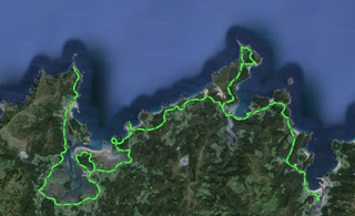
I leave Muxía a little late because I have to fix a flat tire, and due to the delay, I meet a guy who is a member of Traski (see Resources), a mountain group promoting hiking routes along Costa da Morte following the paths I have followed on my way here.

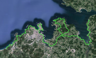
I start going down to Muxía, along Cape Touriñan and the following beaches, a place that is quite isolated from usual tourists, mostly from the Way and going along other interior routes. Our route runs opposite to the one followed by pilgrims, and for more than half of the way, we won’t meet pilgrims.

From Lies, in the middle of today’s stage, we start travelling along pilgrimage tracks, and we meet many people walking in the opposite direction. A few kilometres before Fisterra, we divert rightward and enter the town on the west, through San Martiño, just opposite to the pilgrims’ entrance.

I sleep in Fisterra’s public hostel, and I go out at night to celebrate that I have finished my 44 day bicycle trip, plus the days I spent sightseeing or resting in a campsite or hostel. I have discovered one of the destinations that should be emblematic for pilgrims in Fisterra: the library-bar A Galeria, owned by the Galician writer Roberto Traba Velay, a person I am happy to have met.

If you have been patient enough to read this travel log so far, I sincerely thank you, and if you are interested in telling me something, you can use the comments system or enter de section “About me”, and send me a message. I hope you enjoyed the reading, and I encourage you to use this route to plan a similar trip and discover hundreds of places, and even other places I couldn’t visit.

Stage 44 in Wikiloc: http://en.wikiloc.com/wikiloc/view.do?id=4973684

GPS Track for Stage 44 download: http://goo.gl/KJhH3A

Distances: Muxía – Fisterra 48 km

List of villages:

Download track 44 with QR BIDI

Download track 44 with QR BIDI

Muxía
Lourido
Cuño
Martineto
Viseo
Moreira
Touriñan
Talón
Santo Estevo de Lires
A Canosa
San Martiño
Fisterra

Price of accommodation: 6 euros.

References: A Galería, library-tavern. Rua Real, 25. Fisterra.

Etapa 44 en castellano · Etapa 44 en català

Stage 43: Ponteceso – Muxía

Ponteceso – Muxía
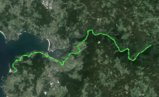
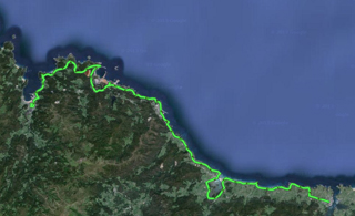
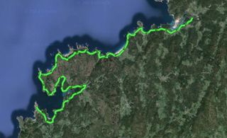
I go to Ponteceso from Filgueira, and go on towards Muxía along the planned coastal route. This stage becomes long and is complicated in several points, since it has trails that are not suitable for cycling, coastal forest trails, and coastal roads.

There is a hard slope before Laxe, and other hard slopes before Cape Villán, but the highest difficulty is posed by the constant slopes up and down which can wear us out. On the other hand, this stage has very few urban areas, and we can see the spectacular landscapes of Costa da Morte and the end of the Way of St. James: Muxía.

In Muxía, it is worth visiting Punta da Barca, with the sanctuary and its ancestral stones, the harbour and Mount Corpiño.

If you take a look at Camino de Santiago > Finisterre and Muxía, you will find additional information about this town and the Way. If we have been collecting stamps for our credential for the last few days, although they are from campsites or coffee shops, they will let us sleep in Muxía’s public hostel, which has very good facilities and a very nice atmosphere. With the stamps on our credential, they will also give us a certificate stating that we have reached the end of the Way.

Stage 43 in Wikiloc: http://en.wikiloc.com/wikiloc/view.do?id=4973679

GPS Track for Stage 43 download: http://goo.gl/A7dLs3

Distances: Ponteceso – Muxía 80 km

List of villages:

Download track 43 with QR BIDI

Download track 43 with QR BIDI

Ponteceso
Neaño
A Carballa
A Telleira
As Grelas
Os Castros
Taboido
San Pedro
A Cruz de Cabalo
Frexufre
O Cabo de Area
Os Peñascales
Laxe
Mordomo
Camelle
Arou
Camariñas
As Carballas
O Cruceiro
Tasaraño
Dor
O Allo
A Ponte do Porto
Porto de Cereixo
Leis de Nemancos
Merexo
Os Muiños
Chorente
A Baiuca
Muxía

Price of accommodation: 6 euros.

Etapa 43 en castellano · Etapa 43 en català

Stage 42: Arteixo – Malpica – Ponteceso

Arteixo – Malpica – Ponteceso
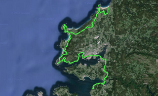
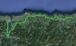
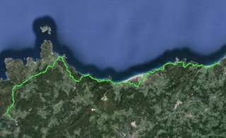
Today’s stage is very intense as regards paths near the water, since most roads and tracks are completely along the coast or cross little coastal forests between one beach and the other. It is also short, but with constant slopes up and down, so you get really tired at the end of the day.

Along the sea path and some roads, I go to Caión, a picturesque town, and from there, to a protected marine environment called Las Marismas de Baldaio, where there is a campsite where I could have stayed yesterday. I go along mountain paths, roads and beach paths among sand dunes, and stop to have something to eat at Arnados beach, at the local restaurant O Cordobés —good, cheap, and highly recommendable.

From Arnados, I go on from one beach to another along some paths in very poor conditions, coastal roads, and forest trails until I get to Malpica de Bergantiños, with my body pretty scratched by the blackberries.

The track leads us to Ponteceso, but I’ve decided to stay in the campsite “Sisargas”, in Filgueira, 4 km away from Malpica de Bergantiños, and 12 km away from Ponteceso by road. The reason is that I wasn’t sure whether Ponteceso had a campsite or a municipal area where camping is allowed.

Stage 42 in Wikiloc: http://en.wikiloc.com/wikiloc/view.do?id=4973660

GPS Track for Stage 42 download: http://goo.gl/4Z8AKC

Distances: Balcobo campsite – Sisargas campsite 54 km

List of villages:

Download track 42 with QR BIDI

Download track 42 with QR BIDI

Gondreo
Caión
Leira
Castrillón
O Outeiro
Razo da Costa
Santa Mariña
O Ceán
Malpica de Bergantiños
A Fonte dos Bois
Filgueira

Price of accommodation:: 11 euros.

References: Camping Sisargas. c/ Filgueira, 12. 15113 Malpica de Bergantiños (A Coruña). Tel. +34.981721702. www.campingsisargas.es

Etapa 42 en castellano · Etapa 42 en català

Stage 41: Pontedeume – Coruña – Arteixo

Pontedeume – Coruña – ArteixoThis stage is long but easy, and has amazing landscapes. The first part, about 20 km long, circles the sea inlet of Betanzos up to the beach of Sada, and is done along roads next to the beach. From Sada, we take roads that lead us to the end of the coast of Dexo, and we go down towards Corunna. Most routes have nearby towns, but our route avoids urban zones as far as possible.

From the town of Perillo, the route will be completely urban until we leave A Coruña, that is to say, a total of 20 km. Our route uses the bike lanes of the city perimeter: the one of the harbour, the old streetcar, the one of the lighthouse, and the one of the sea path that takes us to the outskirts of Corunna, to Estrada Bens.

In Estrada Bens, we will pass by the water treatment plant, which smells pretty bad, then by the seafood reprocessing factories, inhabited by a group of seagulls, and finally by a quarry next to the beach. From that point, we will take a forest trail which will lead us near Arteixo, to a place called Valcovo beach, where there is a campsite with a similar name.

The campsite isn’t wonderful, and you have to pay for hot water in the shower, but there are no other campsites many kilometres around, and I have no choice but to accept it.

Stage 41 in Wikiloc: http://en.wikiloc.com/wikiloc/view.do?id=4973656

GPS Track for Stage 41 download: http://goo.gl/k48UEE

Distances: Ber campsite – Balcobo campsite 90 km

List of villages:

Download track 41 with QR BIDI

Download track 41 with QR BIDI

Boebre
A Herbosa
Perbes
Río de Bañobre
Miño
A ponte do Porco
A Insua
Montecelo
Gandario
Sada
Chaburro
Mosteirón
Piñero
Veigue
Suviña
Cabreira
O Batán
O Seixal
Perillo
A Coruña
Rañobre
Rañal

Price of accommodation: 10 euros

Etapa 41 en castellano · Etapa 41 en català

Stage 40: Pontedeume – Fragas do Eume – Pontedeume

Pontedeume – Fragas do Eume – PontedeumeThis stage wasn’t planned, but since I am only 20 km away from the monastery of Caaveiro, I’ve decided to go up there and visit the forest of river Eume. It will be the third forest I visit after La Garrotxa and Irati. It is a circular tour about 40 km long which can be planned for a whole day, and I have included it here as if it were another stage.

As Fragas do Eume is one of the natural paradises of Galicia. It is made up of the Natural Park Fragas do Eume and the complex of the Mosteiro de San Xoan de Caaveiro. All this is one of the last bastions f the traditional Atlantic forest, and is worth visiting if you follow this route along the north of Iberia or if you go near Ferrol, Corunna or Pontedeume, in the mouth of river Eume.

If you go there, you can go up by bike to the monastery, and from there follow one of the scheduled hiking routes. You have to leave the country and go to the entrance of Pontedeume along the AC-144. After two kilometres, you have to turn left and take the little village road CP-6902 towards Chao de Ombre. On the way, there is a very well known fountain, and at the end of the road, you can find the Natural Park. When cyclists get there, they can go up to the monastery, which can be visited freely, and where we can also find a bar & restaurant.

Learn more about Fragas do Eume: http://en.wikipedia.org/wiki/Fragas_do_Eume

Stage 40 in Wikiloc: http://en.wikiloc.com/wikiloc/view.do?id=4973648

GPS Track for Stage 40 download: http://goo.gl/iOCrel

Distances: Ber campsite – Pontedeume – Fragas do Eume and back 37 km

Download track 40 with QR BIDI

Download track 40 with QR BIDI

Etapa 40 en castellano · Etapa 40 en català

Stage 39: Valdoviño – Pontedeume

Valdoviño – PontedeumeToday, daybreak was sunny. I leave the campsite taking secondary roads, I pass by the A Frouxeira pond, and after As Gorgas, I get to a forest trail which is very badly maintained, so I have to drag my bike for quite a few kilometres until I reach a flat top hill about 300 m high, called A Lagoa. In the middle of the plain, there are ruins of military bases and a geodetic survey monolith, everything very curious and different from what I have seen so far. The routes cross the hills and get to beach towns, such as A Fonte da Tella.

I get to Fontá by mistake, but I take a picture of the Quixote that dominates the entrance of the town, and I come back to the northeast roads, intending to go to Ferrol following the coastline. I get to Ferrol and go on by the sea inlet until I enter the city and cross it up to the bridge over the sea inlet. Then I use a section of the English Way of St. James to travel along suburbs and avoid sections by road. Anyway, I end up entering the N-651 to get to Cabañas and, from there, go to Pontedeume. From Pontedeume to the Ber beach, there are four kilometres that are not hard at all.

There are two campsites. I will stay in the one closer to the beach, called “Camping Ber – A Marola” because it is cheaper and it has new facilities built this year. The owner tells me that “Ber” was turned into Galician, but it actually comes from the Spanish verb “Ver” (“to see”), and it originated from how the beach is geographically oriented: ships going to America centuries ago passed in front of the beach to take geographical references and align with their final destination.

As a whole, I may have pedalled for about 100 km, but it hasn’t been hard, because the slopes are mild, although the temperature has been high throughout the day.

Stage 39 in Wikiloc: http://en.wikiloc.com/wikiloc/view.do?id=4973640

GPS Track for Stage 39 download: http://goo.gl/mKcGNW

Distances: A Lagoa campsite – Ber campsite 99 km

List of villages:

Download track 39 with QR BIDI

Download track 39 with QR BIDI

Lago
Montefaro
Baltar
O Grandal
A Pedreira
As Gorgas
A Fonte da Tella
Vila da Area
O Outeiro
Fontá
O Pieiro
O Confurco
Cariño
San Cristovo
Brión
Malata
Ferrol
Perlío
Pereiro
O Chao da Aldea
Cabañas
Pontedeume
Boebre

Price of accommodation: 6.8 euros.

References: Camping Ber – A Marola. Praia de Ber, 15607 Boebre (Pontdedeume). Tel +34.981438500 www.campingber.es

Etapa 39 en castellano · Etapa 39 en català

Stage 38: Cabo Ortegal – Teixido – Valdoviño

Cabo Ortegal – Teixido – Valdoviño
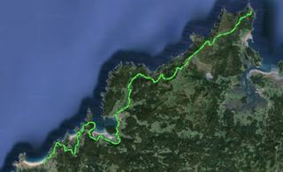
I pedal again until I am near Cape Ortegal, and I cross the peninsula to go up to Teixido along Ruta dos Miradoiros. There is a wet forest and paved forest trails which lead us to the shrine of Santo André de Teixido, near the highest cliffs in continental Europe, and the wind hampers going by bike, but it is worth seeing, at least on foot. There is a popular saying — “A Santo Andrés de Teixido vai de morto o que non foi de vivo”, that is, those who couldn’t visit San Andrés de Teixido when they were alive will go there after death.

You go up about 530 m to Teixido, but halfway there, the whole section starts having mild slopes up and down tending to go down to the beach in Cadeira, and it is all quite even until the end of the stage. The first part of today’s stage is unforgettably beautiful: Teixido, Mount Capelada, the viewpoints, the mountains that go down to Cedeira, etc.

From Cedeira, you can see the water from the roads that follow the coastline, up to Mirador do Paraño, very close to the beach campsite “A Lagoa”, where I spend the night.

Stage 38 in Wikiloc: http://en.wikiloc.com/wikiloc/view.do?id=4973634

GPS Track for Stage 38 download: http://goo.gl/TYE8A9

Distances: Cabo Ortegal – A Lagoa campsite 51 km

List of villages:

Download track 38 with QR BIDI

Download track 38 with QR BIDI

Rabadán
Corveiro
A Graña
A Corredoira
Vilas
Magoira
Malde
As Pontigas
Cedeira
O Barra
Campo da Cruz
Campelo
Pedralba
O Puntal
As Ferrerias
San Xiao
A Gabeira
O Freixo
A Ramalleira
O Talieiro
Marnela de Arriba
A Lagoa
Ladeira

Price of accommodation: 8.6 euros.

References: Camping A Lagoa. Praia A Fouxeira. 15552 Valdoviño. Tel +34.981487122. www.alagoacamping.com

Etapa 38 en castellano · Etapa 38 en català

Stage 37: Viveiro – Cariño – Cabo Ortegal

Viveiro – Cariño – Cabo OrtegalToday is an excellent day, and the slopes expected for this stage are not hard, but for the ones up Cape Ortegal. I leave Viveiro heading to the western coast of the sea inlet, and I pass by villages that are not very populated, up to O Vicedo and Bares, a very nice bay we have to circle. From there, we will turn to Barés and get to the sea inlet of Ortigueira.

If it is possible, it is worth visiting the natural park of Ortigueira, a quick trip with certain landscape interest. Circling Ortigueira, we find many villages with restaurants and tourist facilities, which gradually fade away as we go northwards, up to Cariño, a town we will have to cross before getting to the shrine of San Xiao de Trebo, and then Cape Ortegal. Cape Ortegal lighthouse is 200 m above sea level, and it is a spectacular place with the oldest rocks in the Iberian Peninsula, and where we find the beginning of the GR 50 hiking route, “Rota do Medievo”, very well known in Galicia.

The GPS track ends in San Xiao de Trebo, not in my day’s final destination, and it somehow connects to the track in tomorrow’s stage. We should bear in mind that we have to go up San Xiao de Trebo to connect with the other track, but depending on the town in which we spend the night, we can find different paths to get to Santo André de Teixido tomorrow. In Cariño, I’ve been told that we will likely be allowed to spend the night bivouacking in the surrounding area of San Xiao de Trebo.

As regards accommodation, I had planned to go back 18 km to sleep in Ortigueira, since today is Saturday and next week is one of the best known folk music meetings in Europe, the Celtic Festival: http://www.festivaldeortigueira.com Finally, I have gone to the town, but I haven’t seen any festival atmosphere yet. I will spend the night in a hostel called “La Perla”. It has been one of the best stages of the entire trip, very comfortable and fun.

Stage 37 in Wikiloc: http://en.wikiloc.com/wikiloc/view.do?id=4973627

GPS Track for Stage 37 download: http://goo.gl/4xIFIK

Distances: Viveiro campsite – Cabo Ortegal 95 km.

List of villages:

Download track 37 with QR BIDI

Download track 37 with QR BIDI

Covas
San Román de Vale
O Vicedo
Porto do Barqueiro
O Porto de Bares
O Vila de Bares
Bares
Loiba
Cerdigos
O Porto de Espasante
O Mosteiro
Barbós
Miñano
Ortigueira
Miudelos
Cancelo de Aló
Cuiña
Ribados
A Casanova de Arriba
A Ponte de Mera
Viñán
Veiga
Condomiña
Reboredo
A Ortigueira
A Basanta
A Castañeira
Cariño

Price of accommodation: 20 euros.

References: Pensión-Residencia La Perla. Avenida de la Penela s/n. 15330 Ortigueira. Tel. +34.981400150 / +34.981400151

Etapa 37 en castellano · Etapa 37 en català

Stage 36: Ribadeo – Viveiro

Ribadeo – ViveiroYesterday, I read in La Voz de Galicia that, in the town of Foz, they celebrated an official recognition ceremony for Camiño do Mar, an extension of the Northern Route. So, an association of friends of the Way of St. James is promoting a coastal branch of the pilgrimage. It is a coincidence, but the route we designed for northern Iberia also goes along Camiño do Mar, so today’s stage will be completely along the coast and I will be able to collect some uncommon stamps on my pilgrim credential.

You leave Ribadeo towards the western coast, along paved paths parallel to the beaches, although we will never go down to the water, which is a few meters away from our level. There is a lot of fog and it is raining, but the landscape is worth seeing, and we can cycle easily.

We pass by little picturesque towns in a very long sea path which is paved or has cobblestones, and connects almost all the towns from Ribadeo to Burela, about 50 km long. From Burela to Viveiro, there are more road sections, but they are not very busy. The pier at Morás harbour is curious, 25 km far from our final destination, built on the surface with concrete pieces which are typical of the pier bottom, spread along the coastline.

We only have a hard slope 10 km before Viveiro, but it is not extremely exhausting, and so today’s stage has a minimum difficulty although we have travelled almost 100 km.

Finally, I will stay in Viveiro’s municipal campsite, located in the administrative area of Covas. It is a town in Rías Altas, with an intense cultural life, visited mainly by tourist from Galicia and Asturias. This weekend, they happen to celebrate their traditional Renaissance Market, and everybody dresses up like people from this age. I will stay one more day here to attend this medieval festival.

Stage 36 in Wikiloc: http://en.wikiloc.com/wikiloc/view.do?id=4973626

GPS Track for Stage 36 download: http://goo.gl/j7xPR0

Distances: Pilgrim hostel of Ribadeo – Viveiro campsite 96 km

List of villages:

Download track 36 with QR BIDI

Download track 36 with QR BIDI

Ribadeo
Rinlo
Barreiros
Foz
Nois
Cangas
Burela
San Cibrao
Lieiro
Lago
O Alto do Lago
Morás
Vilapol
Portocelo
Vilachá
Faro
Auga Doce
Celeiro
Viveiro
Covas

Price of accommodation: 10 euros.

References: Camping Viveiro. Cantarrana, s/n, Praia de Covas. 27837 Viveiro (Lugo). Tel. +34.982560004 campingdevivero@gmail.com

Etapa 36 en castellano · Etapa 36 en català

Stage 35: Piñera – Castropol – Ribadeo

Piñera – Castropol – RibadeoThis is the stage in which we enter Galicia and we will stop running parallel to the Northern Route. It may be short or very long, depending on how much we want to pedal, since it may be 55 km or 35 km long based on what we choose —taking the crossing boat in Castropol or cycling around the sea inlet.

This is a stage without ups and downs, with mild slopes and without mountain passes, so it is very attainable to get to Ribadeo by road. We leave Piñera and head to Navia, the biggest town we’ll find today, but it doesn’t have many tourist attractions but for a few clean, well maintained beaches.

Boat Castropol – Ribadeo
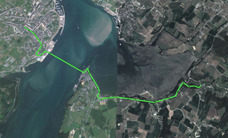
If, when we are near Ribadeo, we want to take the little water-taxi, we will have to go down the right part of the town, along Galicia Avenue, and then go towards the pier walkway. In this Web site, in the Resources section, I have written down the telephone number you have to call to contact the boatman, who only makes on-demand trips. This helps us save 20 km at a price of 5 Euros.

When we are in Ribadeo, there are a lot of lodges available, and there is even a public hostel of the Way of St. James of the Xunta de Galicia. In my case, when I passed by the hostel, I met some people I had seen some days before, and I decided to camp next to the hostel, authorized by Ribadeo government.

Stage 35 in Wikiloc: http://en.wikiloc.com/wikiloc/view.do?id=4973623
Crossing boat in Wikiloc: http://en.wikiloc.com/wikiloc/view.do?id=4973616

GPS Track for Stage 35 download: http://goo.gl/j6m0iI
GPS Track for crossing boat download: http://goo.gl/ZpC2ux

Distances: Pilgrim hostel of Piñera – Pilgrim hostel of Ribadeo 35 km (or 57 km without taking the crossing boat)

List of villages:

Download track 35 with QR BIDI

Download track 35 with QR BIDI

Download track of boat with QR BIDI

Download track of boat with QR BIDI

Piñera
Frejulfe
Andés
Navia
La Reguera
Ortiguera
Medal
Lugar Nuevo
La Caridad
Viavélez
La Muria
Ol
Cabaleiros
Becharro
El Esquilo
Castro
Castropol
Cornayo
A Veiga
Porto de Abaixo
As Casasnovas
Ribadeo

Etapa 35 en castellano · Etapa 35 en català