Category Archives: Daily

Daily stages of North Iberian coast to coast

Stage 24: Zumaia – Bolívar – Zenarruza

Zumaia – Bolívar – Zenarruza
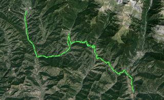
Today it is the summer solstice. This stage is shorter than it would be possible if we go by bike, since it would make sense to go up to Gernika at least, but I have decided to stay in Ziortza-Bolíbar, to spend the night at Zenarruza monastery inn, since my leg’s muscles ache and I find it difficult to go on normally.

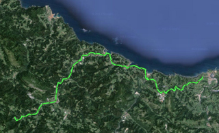
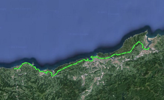
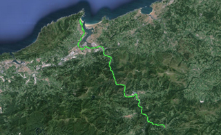
The first eleven kilometres are through internal forest trails, until we go towards the coast and get to Deba, from there, to Mutriku, to Ondarroa, and we get inland and do the last 20 km by mountain roads and tracks. I have to travel by roads because the conditions of the Way tracks are quite dangerous and terrible.

In Bolibar, when it is open, you can visit the museum devoted to Simón Bolívar, but I haven’t had the chance to see it yet because the opening times are weird and do not fit the tourist logic. Bolibar has a museum devoted to Bolívar because his father’s family was from this town. Zenarruza is a monastery located two kilometres from Bolibar, a quiet place, perfect to get some rest and for meditation.

Stage 24 in Wikiloc: http://en.wikiloc.com/wikiloc/view.do?id=4973495

GPS Track for Stage 24 download: http://goo.gl/ds0l8S

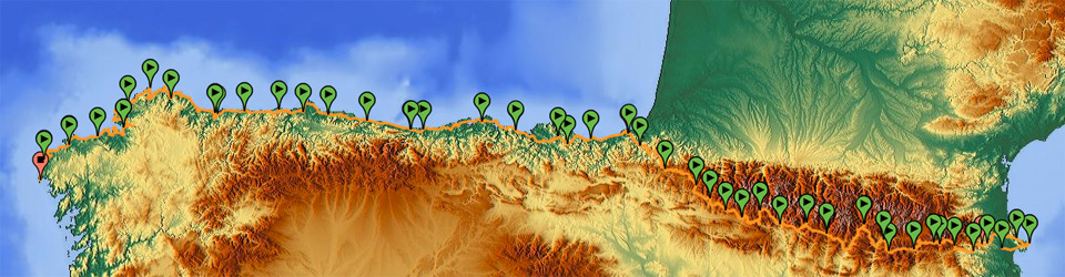
Distances: Albergue Santa Klara – Zenarruza Monastery 41 km

List of villages:

Download track 24 with QR BIDI

Download track 24 with QR BIDI

Zumaia
Itziar
Deba
Mutriku
Ondarroa
Markina-Xemein
Ziortza-Bolíbar
Zenarruza

Etapa 24 en castellano · Etapa 24 en català

Stage 23: Irún – Zumaia

Irun – Zumaia
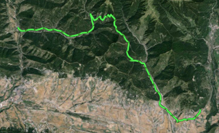
This is a classic stage of the Way of St. James, but avoids the sections which are not suitable for mountain bikes, and offers alternatives through forest trails and roads. Up to Pasaia, we go along paths and forest trails, with mild slopes, and in quite poor conditions due to the winter and spring rains. In Pasaia, we cross the sea inlet on a water taxi, and get to the end of Donostia through urban areas. From Donostia to Orio, we will go through forest trails, and from Orio to Zumaia, through coastal roads.

From Irún to Zumaia, there are many towns, the most important of which is Donostia/San Sebastián, which we will cross along the coastal perimeter, and it is a perfect place to sit and have something to eat.

In Zumaia, there is an interesting accommodation and gastronomic offer —we can find from a parish hostel of the Way to luxurious hotels. I have chosen a place that is somehow special outside the town, about two kilometres from the centre. It is called “Santa Klara”, and it is a hotel with an attached building used as a hostel, with hotel comforts and special prices for pilgrims. It is a quiet place, very friendly, highly recommended for all types of tourists. What is more, if you want to walk around the town, the owners take guests to and from the town at arranged hours.

As regards the landscape offer, Zumaia leaves us speechless, both if we want to walk around the town, and if we want to visit the surrounding area, with the Itzurun beach as one of the natural references of the coast for all Guipuzkoa. It is worth seeing this beach, walking around the sea inlet, and visiting the lower urban area where the bars and the commercial and social centre of the village can be found.

Stage 23 in Wikiloc: http://en.wikiloc.com/wikiloc/view.do?id=4973491

GPS Track for Stage 23 download: http://goo.gl/XJ7HIO

Distances: Pilgrim hostel of Irún – Albergue Santa Klara 62 km

List of villages:

Download track 23 with QR BIDI

Download track 23 with QR BIDI

Irún
Pasaia
Donostia/San Sebastián
Orio
Zarautz
Getaria
Zumaia

Price of accommodation: 20 euros.

References: Agroturismo Santa Klara. Calle de los diseminados 4, 20750 Zumaia (Gipuzkoa). Tel. +34.943860531. www.agroturismosantaklara.com

Etapa 23 en castellano · Etapa 23 en català

Stage 22: Etxalar – Bera – Hondarribia – Irún

Etxalar – Bera – Hondarribia – IrunFrom Etxalar, I went to Bera de Bidasoa, and from there, I went down to the sea, to Hondarribia, to close the first section of the coast to coast trip. I got to the Atlantic Ocean through the Pyrenean Axis, after completing more than 1,000 km by mountain bike.

Important alternative to the Transpyrenean route

From Etxalar, I haven’t taken the traditional Transpyrenean Route. My bike broke down yesterday and I don’t have the proper tools or replacement parts to fix it completely. I went to a repair shop specialized in bikes, Katea-Bike, in Bera de Bidasoa, to repair it. It was a good choice —they are excellent professionals, and the prices are fair; at the bottom of the card, you’ll find the information.

To go to Bera, we deviated quite a lot from the initial way, and did not pass by the French slope. The entire trip was along Spanish administration land, but we avoided the roads, and could go along a Greenway connecting Bertiz Natural Park with Irún, passing by Bera. It is an alternative to the classic Transpyrenean tour; the difference is that the whole way is down, with a smooth slope with no difficulties.

The next graph shows the differences between the classic route —right, blue line— and the alternative through the greenway —left, green line.

Important alternative to the Transpyrenean route (in green)

Important alternative to the Transpyrenean route (in green)

Interactive map of the Bertiz greenway: https://maps.google.com/maps/ms?ie=UTF8&hl=es&msa=0&msid=216807157426420720565.00049773827891a1aaebc&z=10

If we follow the GPS track I provide here, we get to Hondarribia, and then we go back to Irún, where I spend the night in the municipal pilgrim hostel of the Way of St. James. At first, the traditional Transpyrenean tour ends here, but if we use the following track, we will get to Donostia/San Sebastián, which is the final point of the new, extended Transpyrenean tour and of the Transpyr.

Stage 22 in Wikiloc: http://en.wikiloc.com/wikiloc/view.do?id=4973475

GPS Track for Stage 22 download: http://goo.gl/K9l4uR

Distances: Albergue Tompalenea – Pilgrim hostel Irún 36 km

List of villages:

Download track 22 with QR BIDI

Download track 22 with QR BIDI

Etxalar
Bera
Zalaín
Endarlatza
Irun
Hondarribia

Price of accommodation: 10 euros.

References: Workshop and Bicycle Shop Katea Bike. Kanttonberri, núm. 1 – 31780 Bera de Bidasoa. Tel. +34.948631218 kateabera@telefonica.net

Etapa 22 en castellano · Etapa 22 en català

Stage 21: Orreaga/Roncesvalles – Etxalar

Orreaga/Roncesvalles – Etxalar
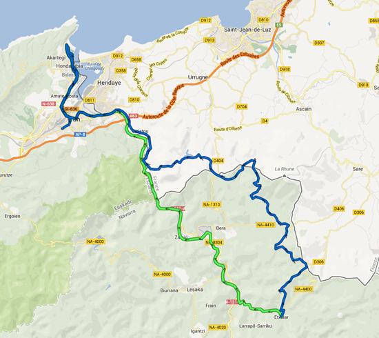
You leave Orreaga and go up a little mountain pass, Ibañeta, by road, before getting to a forest trail next to the shrine of San Salvador. From there, we will go down towards the valley of Aldudes, under French administration, in an endless and impressive descent.

The next ascent has a very steep slope, up to the mountain pass of Elorrieta, and from there, you go down to Elizondo. This is a good town to rest for a while and regain strength, since the next 25 km are really hard. Besides the poor conditions of the tracks, a great deal of the trip is along trails, and in my case, there is thick fog and intermittent rain. The landscape is spectacular, but the path is dangerous and we should be careful.

In Etxalar, there are no campsites, but I stay in a friendly hostel called “Tompalenea,” owned by a very nice man called Santiago Elizagoien. It is worth sleeping under shelter because the weather is bad, and Etxalar is a very wet town. I will stay one more day in the hostel since it is raining heavily, and I will make the most of the time to have some rest for a day and prepare the next set of stages of the route beyond the Pyrenees.

I have lost my recorded track of this stage, but instead of reproducing it on the map, I provide Zinaztli’s track, since my route follows exactly its steps. The main difference is that it took me two more hours to end this stage.

Stage 21 in Wikiloc: http://en.wikiloc.com/wikiloc/view.do?id=4973465

GPS Track for Stage 21 download: http://goo.gl/L52Acp

Distances: Pilgrim hostel of Roncesvalles – Albergue Tompalenea 70 km

List of villages:

Download track 21 with QR BIDI

Download track 21 with QR BIDI

Orreaga/Roncesvalles
Banca
Erratzu
Bozate
Arribiltoa
Elizondo
Orizki
Etxalar

Price of accommodation: 13 euros.

References: Albergue Tompalenea (Santiago Elizagoien). Etxalar (Navarra). Tel. +34.948635166 / +34.689702891

Etapa 21 en castellano · Etapa 21 en català

Stage 20: Izaba – Orreaga/Roncesvalles

Izaba – Orreaga/Roncesvalles
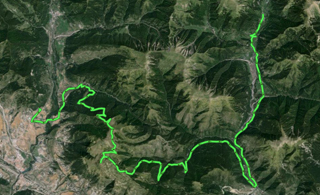
The first part of this stage is by road. You go up two mountain passes, of progressive difficulty, until you get to a high point of 1,300 m. In this point, you start moving along the forest trail, and you enter the natural park of the Irati rainforest, the biggest forest in Navarre. Almost a third of the stage is done in Irati, and it is a spectacular landscape. When you go out of Irati, you follow village roads to the weapons factory of Orbaizeta, and from there, you go up forest trails to Orreaga.

Orreaga/Roncesvalles is a small town, but it is also the starting point of the French Way of St. James, and there is a slightly varied accommodation offer. I have stayed in the pilgrims’ hostel, which is very welcoming, and I’ve got a pilgrim credential and been socializing. The credential will be useful if I want to use the Way accommodation network when I travel along the coast of Cantabria. Learn more of Orreaga/Roncesvalles

It is one of the few stages of the Trans Pyrenees Route that go through forests, in wet areas covered by vegetation, which hasn’t been seen since La Garrotxa, in Catalonia. It is difficult, not because of the slopes or the conditions of the trails, but because it is a quite long stage. You have to carry water because, although we are in the middle of the forest, there are no water sources, and we can only get water if the ravines bring down snowmelt water or in some of the torrents near Irabia reservoir.

Stage 20 in Wikiloc: http://en.wikiloc.com/wikiloc/view.do?id=4973460

GPS Track for Stage 20 download: http://goo.gl/c671Jx

Distances: Aterpe Oxanea – Pilgrim hostel in Roncesvalles 73 km

List of villages:

Download track 20 with QR BIDI

Download track 20 with QR BIDI

Izaba
Uztarroze
Fábrica de Orbaizeta
Orreaga/Roncesvalles

Price of accommodation: 6 euros

Etapa 20 en castellano · Etapa 20 en català

Stage 19: Hecho – Izaba

Hecho – IzabaToday, I have also decided to travel by road. This is because I would like to pass by Roncal, and if I follow the Trans Pyrenees route, when I arrive in Ansó, I will have to divert northward and enter Navarre from another site.

I travel by road from Hecho to Ansó, a very picturesque town which is worth visiting. From there, I go to Roncal Valley by road and I get into Navarre. I cross the mountain pass separating the two provinces, and I go down to Garde, at the bottom of the valley, and from there, to Izaba, It is a very short and quiet stage, by road. You go up two mountain passes, and all the landscapes are worth seeing.

In Izaba, there are no campsites, but there is a good accommodation offer, including the “Oxanea” hostel, where I spend the night. The atmosphere is very good, since all the hostel guests are hikers or cyclists, there are no conventional tourists.

Stage 19 in Wikiloc: http://en.wikiloc.com/wikiloc/view.do?id=4973445

GPS Track for Stage 19 download: http://goo.gl/ezG3zY

Distances: Valle de Hecho campsite –  Oxanea hostel  38 km

List of villages:

Download track 19 with QR BIDI

Download track 19 with QR BIDI

Ansó
Garde
Roncal
Urzainqui
Izaba

Price of accommodation: 13 euros.

References: Aterpe Oxanea. Izaba (Nafarroa). Tel. +34.948893153

Etapa 19 en castellano · Etapa 19 en català

Stage 18: Castiello de Jaca – Hecho

Castiello de Jaca – HechoThis stage leads to Aragüés by a mountain road, so the classic Transpyrenean Route is not altered, but I’ve made a minor variation from Aragüés, since I am following the advice given to me by people who know the area I would have to pass by and who have told me the conditions of the paths are disastrous. I have changed the planned trip and gone by route from Castiello to Hecho, where there is a campsite, instead of reaching Navarre via Urdués.

The stage by mountain road has an interesting landscape, but it is not as fun as the forest trails. But there are not many mountain trails in today’s stage, and there are many trails that are not suitable for cycling, due to the conditions of their surface and the vegetation that gathers on them. Anyway, they are fixing the local road connecting Aragüés with the provincial road A-176, the one which leads to Hecho, and this experience is like cycling along unpaved tracks.

I arrive in Hecho very soon, at about 2 p.m., but instead of going on to Roncal, I will stay in the municipal campsite “Valle de Hecho”. The Trans Pyrenees route goes on just by the campsite, so tomorrow I won’t have to make extra kilometres to come back to the marked route.

Stage 18 in Wikiloc: http://en.wikiloc.com/wikiloc/view.do?id=4973438

GPS Track for Stage 18 download: http://goo.gl/p3FV17

Distances:  Solopuent campsite – Valle de Hecho campsite  43 km

List of villages:

Download track 18 with QR BIDI

Download track 18 with QR BIDI

Castiello de Jaca
Aratorés
Borau
Aisa
Jasa
Aragüés del Puerto
Hecho/Echo

Price of accommodation: 12.5 euros.

References: Camping Valle de Hecho. Ctra Puente la Reina s/n – Hecho/Echo. Tel. +34.974375364 www.campinghecho.com

Etapa 18 en castellano · Etapa 18 en català

Stage 17: Senegüé – Castiello de Jaca

Senegüé – Castiello de JacaToday’s stage was shorter than I had planned, since I wanted to reach Aragüés del Puerto, but I ended up in Castiello, 18 km away from Aragüés, but the closest point with a campsite.

The stage is just half as long as the previous one, and with better land and a better trip, since the ascent seems to be less hard and the soil is generally in better conditions.

The only problem I had was due to constant rainfall and the water going down in the watersheds. The route makes you cross river Aurín before getting to the town of Barrés, and that would not cause any further complications than soaking your feet in cold water, but due to the volume of water flowing down, I had to cross the river with the water up to my waist, and a high risk of losing the bike and luggage due to the strength of the current. The water stripped me of my bathing shoes, and I had to cross half the river barefooted.

Finally, I arrived without any problems in Castiello de Jaca, and I stayed in the only campsite there, “Solopuent.”

Stage 17 in Wikiloc: http://en.wikiloc.com/wikiloc/view.do?id=4973435

GPS Track for Stage 17 download: http://goo.gl/V74KVP

Distances:  Valle de Tena campsite – Solopuent campsite 33 km

List of villages:

Download track 17 with QR BIDI

Download track 17 with QR BIDI

Senegüé
Barrés
Isín
Larrosa
Vilanovilla
Bescós de Garcipollera
Castiello de Jaca

Price of accommodation: 17 euros.

References: Camping Solopuent. Ctra. Garcipollera s/n. 22710 Castiello de Jaca. Tel. +34.974350046 www.solopuent.com

Etapa 17 en castellano · Etapa 17 en català

Stage 16: Torla – Senegüé

Torla - Senegüé
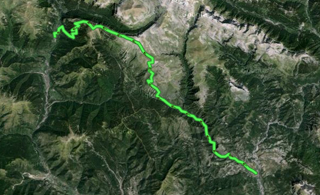
From Torla to Fiscal, you go by road, a section that is about 20 km long and is completed quickly, but one of the hardest stages of the whole Trans Pyrenees Route starts in Fiscal. The main reason is the conditions of the forest trails, which are very damaged by the effects of winter.

From Fiscal to Senegüé, in June 2013, we basically find tracks full of mud and loose rocks and soil, and cycling is only possible in areas of compacted soil, which cannot be found at all from an altitude of 1,600 m. From Santa Orosia shrine, where there is a water source, and 20 km from there, there are very few trails that are suitable for cycling and the stage becomes very long.

All this made me spend a lot of time in the highest part of the stage, Oturia crag, and I have to spend the night at an altitude of 1,700 m with the tent. The next day, it took me three hours to get to Senegüé, although all the way is descending or even, but it is full of branches from the forest cleaning, water, and quite many centimetres of mud in all the shady areas.

In Senegüé, I enjoy the day resting and staying in “Valle de Tena” campsite, the one I wanted to reach the previous day.

Stage 16 in Wikiloc: http://en.wikiloc.com/wikiloc/view.do?id=4973432

GPS Track for Stage 16 download: http://goo.gl/1v09vh

Distances: Río Ara campsite – Valle de Tena campsite  68 km

List of villages:

Download track 16 with QR BIDI

Download track 16 with QR BIDI

Torla
Fiscal
Bergua
Casbas
Oliván
Larrede
Senegüé

Price of accommodation: 9.5 euros.

References: Camping Valle de Tena. Ctra. 260, km 513-460. 22666 Sorripas – Senegüé. Tel. +34.974480977 www.campingvalledetena.es

Etapa 16 en castellano · Etapa 16 en català

Stage 15: Puyarruego – Torla

Puyarruego – TorlaI had to stay in the campsite for three days because it didn’t stop raining. It is an atypical June: it rains every day and it is pretty cold, which keeps the snow on the hulls during mid-June. The water build-up begins to be noticeable in the Pyrenees, since it has made the river level to go up, and there already are some permanent alerts by the Civil Defence services. Important floods are starting to strike in the Catalonian Pyrenees.

Finally, today I set out to go on with the route I’ve planned. By road, I passed by the Añisclo Canyon towards Los Sestrales crag, and I arrived in Nerín. I went up a forest trail and, as from an altitude of 2,000 m, I found plenty of snow, fog and cold. I went through dangerous sections which delayed me a lot, and I was finally forced to spend the night in Torla, in one of the campsites of the town, “Río Ara,” because it was getting late.

Stage 15 in Wikiloc: http://en.wikiloc.com/wikiloc/view.do?id=4973422

GPS Track for Stage 15 download: http://goo.gl/yjfonz

Distances:  Valle Añisclo campsite – Río Ara campsite 50 km.

List of villages:

Download track 15 with QR BIDI

Download track 15 with QR BIDI

Puyarruego
Nerín
Torla

Price of accommodation: 9.20 euros.

References: Camping Río Ara. 22376 Torla (Huesca). Tel +34.974486248. www.ordesa.net/camping-rioara

Etapa 15 en castellano · Etapa 15 en català